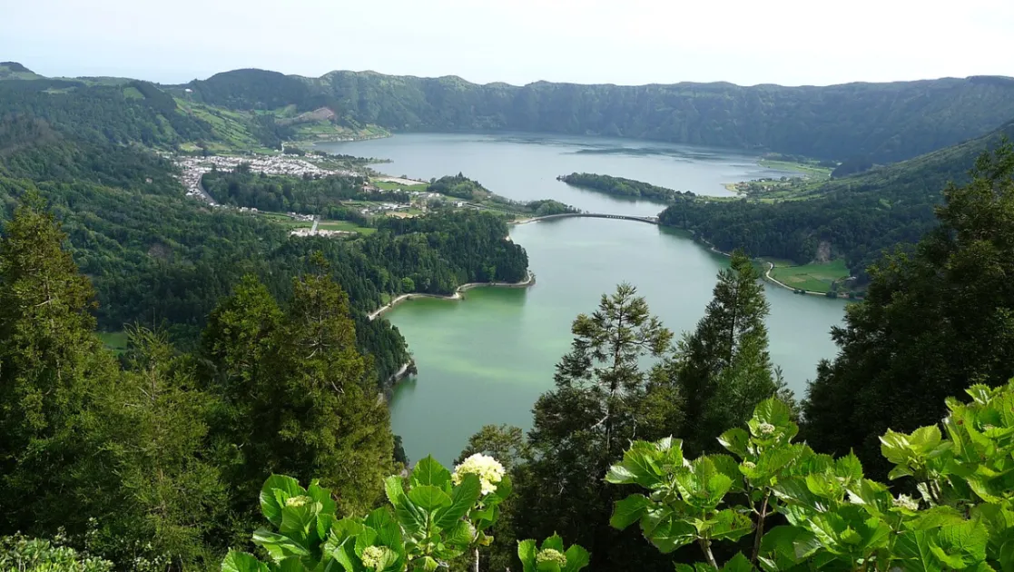
For many travellers Sete Cidades is the picture that sums up São Miguel: two lakes side by side, one blue and one green, at the bottom of a volcanic crater on the far west of the island. Visit Azores presents the Protected Landscape of the Sete Cidades Lake as one of the 7 Natural Wonders of Portugal, and the reputation is earned.
This guide pulls together what you need to plan a visit: the legend of the lakes, the viewpoints (starting with Vista do Rei), the trail that drops from the crater rim and loops around Lagoa Verde, the village below, and what is worth confirming before you leave.
Overview: the Sete Cidades crater
Lagoa das Sete Cidades is in practice a pair of linked lakes, Lagoa Azul and Lagoa Verde, surrounded by green slopes inside a volcanic caldera. The quiet village of Sete Cidades sits on the crater floor, and a traditional bridge connects the two lakes.
The most repeated explanation for the two colours is that Lagoa Azul reflects the sky while Lagoa Verde reflects the green slopes around it. That is a popular explanation in travel guides, not a scientific measurement, so treat it as such. For your visit, what matters is that visibility changes quickly: leave plenty of time to wait for the clouds to open.
The legend and the other lakes
According to the legend told by Visit Azores, the two lakes were formed from the tears of a shepherd and a princess who shared a forbidden love. AllTrails summarises the same story as the legend of the impossible love of the shepherd and the princess, tied to the bridge that joins the lakes.
Smaller lakes lie nearby. A guide from Azores Getaways lists Lagoa de Santiago, Lagoa Rasa, Lagoa do Canário, the Lagoas Empadadas and Lagoa do Caldeirão. According to that source, Canário is easy to reach, while some of the others are more secluded or only reached on trails. Always confirm access on the ground before setting out.
Viewpoints: Vista do Rei and more
Vista do Rei viewpoint
This is the most famous one. The name honours King D. Carlos and Queen D. Amélia and marks their visit to the island in 1901. From here you see both lakes, the village and the slopes around them. It is also the starting point of the trail described below. A recent hiker mentions free parking at the site; check how things look when you arrive.
Grota do Inferno viewpoint
It lies near Lagoa do Canário and is described as one of the best photo spots on the island. It requires a short walk. The source we consulted uses both Grota do Inferno and Boca do Inferno, so look for the signs on site.
Cumeeiras viewpoint
On the edge of the crater, it opens views over the village, both lakes, the coastline and the Atlantic. In clear weather it is a good companion to Vista do Rei. To compare with other viewpoints across the archipelago, read the 20 best viewpoints in the Azores and browse the viewpoints list; if you are carrying a camera, the photography guide helps you choose the hour.
The Vista do Rei to Lagoa Verde trail
According to AllTrails, the most popular route among hikers is a 12.6 km circuit with 405 m of elevation gain, rated moderate. It starts at the Vista do Rei viewpoint, drops into the crater, goes around Lagoa Verde and returns to the start. AllTrails is a community platform, so use the numbers as a guide and confirm the route status from local signs and Visit Azores.
What it is like, section by section
A hiker who walked the circuit in October 2026 describes four parts: a fairly flat stretch on a dirt track along the caldera ridge; a very steep descent on a poorly paved road to the village; an easy stretch beside the lake and through the village, with views of the two-coloured water; and, at the end, a steep climb on a clay forest path and up a rocky gully. They recommend going clockwise, which is also what the app suggests.
According to the same listing, the surface is about 45% gravel (5.7 km) and 24% paved (3.1 km), with packed earth and loose gravel. The same report flags an unmaintained stretch, with a small off-trail detour around an eroded spot, and the listing mentions mud and overgrown vegetation. Wear hiking footwear with good grip, take a windproof waterproof jacket and enough water, as the description itself advises.
Shorter alternatives
Azores Getaways mentions two walking routes: PR03 SMI - Vista do Rei, a linear trail of about 7.7 km, and PRC05 SMI - Serra Devassa, a 5 km circuit along the upper caldera with views of Lagoa do Canário. Distances and trail conditions can change, so confirm them with Visit Azores before you go. For more ideas, see the trails list and the 10 best Azores hiking trails.
The village, the church and Monte Palace
Down in the crater, the village of Sete Cidades has the Church of São Nicolau, built in the 19th century in neo-Gothic style with a basalt facade, according to Azores Getaways. The road that descends from the viewpoints to the village is known for its hydrangeas; to learn when they bloom, read hydrangeas in the Azores.
On top of the caldera stands the former Monte Palace Hotel, opened in 1989 with 88 rooms and closed about two years later. It is now abandoned. It is one of the most photographed buildings on the island, but it is in ruins: look at it from outside and respect any access warnings.
On the water, the same guide mentions stand-up paddleboarding, kayaking and canoeing, and on land cycling and horse riding. We have not confirmed operators, schedules or prices; ask at the local tourist office and read the kayak and SUP guide. The AllTrails listing also shows a campsite at Sete Cidades; check conditions and rules directly before counting on it.
Practical tips for planning your day
Azores Getaways suggests starting at the viewpoints and only then exploring the lakes up close, and that makes sense: you see the landscape from above while the sky is open. Azores weather is unsettled, so bring layers and check the month-by-month weather guide; for your bag, see the packing list.
Sete Cidades is on the far west of São Miguel. To fit it into the rest of your trip, see São Miguel by area, day trips from Ponta Delgada or one week in São Miguel. On the ground, confirm road conditions, parking and what is open in the village, and check the forecast before committing to the trail: the descent is steep and reports mention mud.
For the wider picture, open the São Miguel island page. The official page for the Protected Landscape of the Sete Cidades Lake on Visit Azores is a good starting point for up-to-date information.
FAQ
Why is one lake blue and the other green?
The most common explanation in guides is that Lagoa Azul reflects the sky and Lagoa Verde reflects the green slopes. The local legend says the lakes were formed from the tears of a shepherd and a princess.
Where does the name Vista do Rei come from?
According to Visit Azores, the viewpoint is named after King D. Carlos and Queen D. Amélia, in memory of their visit to the island in 1901.
How long is the trail to Lagoa Verde?
The AllTrails circuit from Vista do Rei is 12.6 km with 405 m of elevation gain and is rated moderate. PR03 SMI - Vista do Rei is linear and about 7.7 km, according to Azores Getaways. Always confirm with Visit Azores.
Can I visit the Monte Palace Hotel?
The hotel opened in 1989, closed about two years later and is abandoned. View it from outside and respect warning signs on site.
What should I take on the trail?
Hiking footwear with good grip, a windproof waterproof jacket and enough water. The route has steep sections with mud and loose gravel.
Final thoughts
Sete Cidades rewards people who give it time: a viewpoint under clear skies, the descent to the village, a stroll by the lake and a return on a trail that asks something of your legs. Combine the viewpoints, pick the route that fits your pace and leave slack for the weather to change.
Before you set out, confirm trail and access conditions with Visit Azores and on the ground. The figures in this guide come from public sources and hikers' reports, and they can change.