The Azores are nine volcanic islands in the middle of the North Atlantic. Almost every landscape you will photograph there, from crater lakes and lava caves to steaming valleys and dark cinder cones, was built by fire and then shaped by water, wind and time. This guide explains in plain terms how the archipelago formed, which kinds of volcano exist, and where to see the best examples island by island.
The facts below come from the Azores Geopark and from the educational and scientific material it publishes. Where practical details such as access, opening times or prices matter, we tell you who to check with instead of guessing.
How the islands formed
The archipelago lies in the middle of the North Atlantic, spread along a strip of roughly 600 km that runs from west-northwest to east-southeast. It has nine islands, a few islets and the surrounding seabed, divided into three groups: the western group (Corvo and Flores), the central group (Faial, Pico, São Jorge, Graciosa and Terceira) and the eastern group (São Miguel and Santa Maria).
The reason for so much volcanism is the location. The Azores sit at the junction of three lithospheric plates, the American, the Eurasian and the African (also called Nubian) plate, with several tectonic alignments crossing the area, the Mid-Atlantic Ridge among them. It is a very complex geodynamic zone with important seismic and volcanic activity.
The Mid-Atlantic Ridge
The ridge is an underwater mountain chain where new oceanic crust is created. In the Azores it lies between the western and central groups, 115 km west of Capelinhos, at depths between 840 and 3,000 metres, and it spreads at an average of about 2 cm a year. Faults and fractures roughly perpendicular to the ridge gave the magma a way up, and that magma built the islands. Deep hydrothermal fields such as Lucky Strike and Menez Gwen are linked to the same ridge.
Not all at once
The islands did not appear together, and none was made in a single go. Formation began about 35 million years ago, when volcanic episodes lifted the seabed around what is now Santa Maria. The first island emerged about 8 million years ago, and it was Santa Maria. Since then explosive, effusive, submarine and subaerial episodes have shaped the others. The youngest island is Pico, at about 270,000 years old.
Types of volcano in the Azores
Volcanologists currently recognise four groups in the archipelago:
- 14 polygenetic volcanoes: large central volcanoes, usually with a caldera, built by many eruptions over thousands to tens of thousands of years;
- 9 of those polygenetic volcanoes are considered active;
- 8 zones of fissural volcanism, where lava rose along cracks instead of a single central vent;
- about 1,750 monogenetic volcanoes: small cones made by a single eruption.
The polygenetic volcanoes are, on São Miguel, Sete Cidades, Fogo, Furnas and Povoação; the submarine Banco D. João de Castro; on Terceira, Santa Bárbara, Pico Alto, Guilherme Moniz and Cinco Picos; on Graciosa, the Caldeira; on Pico, Montanha do Pico and Topo; on Faial, the Caldeira; and on Corvo, the Caldeirão.
The nine active ones are Sete Cidades, Fogo and Furnas, Banco D. João de Castro, Santa Bárbara, Pico Alto, the Graciosa Caldeira, Montanha do Pico and the Faial Caldeira. Active here means they can erupt in the future, but they give warning signs first, such as the release of gases, deformation of the ground and some earthquakes.
Monogenetic volcanoes erupt once, for days, months or a few years, and usually never again. Depending on the material and on whether the eruption was at sea or on land, they form scoria cones, pumice cones, tuff cones or domes. Examples named by the Geopark's educational material include Pico do Facho on Santa Maria, Pico da Esperança on São Jorge, Coroinha on Corvo, the Pico da Sé dome on Flores, Morro do Castelo Branco on Faial and Pico do Alferes on São Miguel.
The Azores UNESCO Global Geopark
The Azores Geopark is presented as a UNESCO Global Geopark. On its official website, azoresgeopark.com, you will find the geosites, geotourism suggestions and educational activities. The Geopark covers 121 geosites, sites of geological interest that were assessed and ranked as of international, national or regional and local relevance.
The geosites that give the archipelago its international character include Montanha do Pico, the Caldeira and Furna do Enxofre on Graciosa, the Capelinhos volcano on Faial, Algar do Carvão on Terceira, the Furnas volcano caldera on São Miguel, and the Mid-Atlantic Ridge with its hydrothermal fields.
Since 2010, with the Geopark in place, protecting and explaining this heritage has become a shared task that involves local people. For a visitor, the practical result is that many of these places have interpretation material, and some have a visitor centre.
Volcanic sites island by island
Faial: Capelinhos
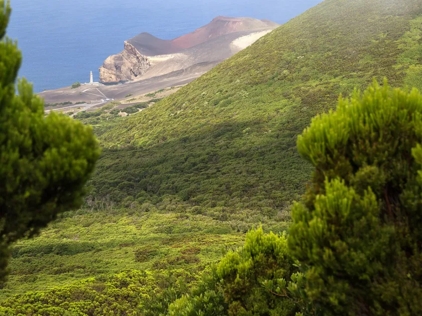
The Capelinhos volcano is the most recent and westernmost of the volcanoes of the Capelo peninsula, on Faial. The eruption began at sea on 27 September 1957, with large explosions and plumes of ash, steam and gas. In November the volcano joined Faial, and in May 1958 the eruption became a land eruption, building a scoria cone and sending out basaltic lava flows. It ended on 24 October 1958.
Today you can see the fossil cliff of Costado da Nau, walk through the barren landscape and climb to the old lighthouse. The Capelinhos Volcano Interpretation Centre, buried in the ashes of 1957/58, tells the story of the eruption and of Azorean volcanism. Our complete guide to Faial covers the rest of the island.
Pico: the mountain
Montanha do Pico, on Pico, rises to about 2,350 metres and is the highest point in Portugal. It is also the youngest and largest polygenetic volcano in the Azores, rising 3,500 metres above the seabed, and the third largest volcano in the North Atlantic. At 2,250 metres there is a circular collapse crater about 550 metres across, whose floor is filled with pahoehoe lava from the small Piquinho cone. Fumaroles occur on top of the cone and on the eastern flank.
The Casa da Montanha has information that helps you read the mountain. If you plan to go up, read our practical guide to climbing Montanha do Pico, and for the volcanic soils of the vineyards, Pico Island: UNESCO vineyards, wine and volcano.
Graciosa: Caldeira and Furna do Enxofre
On Graciosa, the Caldeira sits on top of the smallest stratovolcano in the Azores. It is up to 1.6 km across and holds two small hydromagmatic cones and a marshy area. Beneath it lies the Furna do Enxofre, a volcanic cavity with a perfect vaulted roof, 194 metres long and 40 metres high in the centre. A cold-water lagoon and a fumarole field with carbon dioxide emissions and a mud fumarole share the interior. The Furna do Enxofre visitor centre gives access to the cavity.
Terceira: Algar do Carvão
Algar do Carvão lies in the centre of Terceira and is a volcanic chimney 80 metres deep. In places the roof and walls have collapsed, and elsewhere they are lined with volcanic glass (obsidian). Rainwater feeds a clear lake and builds opal stalactites and stalagmites up to about 1 metre long, described as among the most beautiful and rare in volcanic cavities anywhere. The geosite ranks in the world top 10 of volcanic cavities for mineral deposits.
Terceira also has the Santa Bárbara, Pico Alto, Guilherme Moniz and Cinco Picos volcanoes. For caves in more detail, see our guide to the volcanic caves of the Azores.
São Miguel: three calderas and a hot valley
São Miguel has four polygenetic volcanoes. Sete Cidades, Fogo and Furnas are classed as active, and Povoação is the fourth. For the western caldera and its lakes, see Sete Cidades: twin lakes, viewpoints and the rim trail.
The Furnas volcano is a polygenetic volcano with a complex of collapse calderas, the outer and older one elliptical and up to 8 km across. Inside there are several trachytic monogenetic volcanoes, such as the Pico do Gaspar dome with the pumice ring of Lagoa Seca and the Cova da Burra dome, tied to historic eruptions in the caldera in the mid-15th century and in 1630. From the Pico do Ferro viewpoint you see the whole caldera, the lake and the fumarole fields. More detail in Furnas Valley: fumaroles, lake and what to see, and for another crater lake, Lagoa do Fogo.
The volcano is also at the table and in the water: Furnas is where you can taste the famous cozido, learn about it in Cozido das Furnas and geothermal cooking, and bathe in thermal springs and pools whose water has recognised therapeutic properties.
The other islands
Santa Maria is the oldest island, where the story began, with scoria cones such as Pico do Facho. São Jorge has fissural volcanic complexes at Topo, Manadas and Rosais. Flores and Corvo are on the western side of the ridge; Corvo has the Caldeirão volcano and Flores the Pico da Sé dome. For hiking and viewing across all islands, browse our trails.
Eruptions in history
Since the islands were settled, 26 historical eruptions have been described, 14 submarine and 12 subaerial. The most recent were Capelinhos in 1957/58, which added new land to Faial, and the Serreta volcano in 1998/2001, a submarine eruption off Ponta da Serreta on Terceira.
The Capelinhos eruption left a mark on the whole island: the population was displaced and there were important migration flows to the United States. That human side is part of what the interpretation centre explains.
Visiting well
Several of these sites have visitor centres or houses: the Capelinhos interpretation centre, the Furna do Enxofre visitor centre, the Algar do Carvão visitor house and the Casa da Montanha. We do not publish opening hours or ticket prices, because they change. Check them on the Geopark website or with the local tourism office before you go.
Crater rims, summits and caves depend on weather and on rules that can change, so confirm access on the day and stay on marked paths. For ideas on where to stand, use our lists of viewpoints and trails.
After a volcanic day, the coast offers another side of the same rock: see the natural volcanic rock pools of the Azores.
FAQ
Are the Azores volcanoes still active?
Yes. Nine polygenetic volcanoes are considered active, which means they could erupt in the future and would give warning signs such as gas release, ground deformation and some earthquakes. The most recent eruptions were Capelinhos in 1957/58 and the Serreta volcano in 1998/2001.
Which Azores island is the oldest and which the youngest?
Santa Maria is the oldest. It emerged about 8 million years ago. Pico is the youngest, at about 270,000 years.
How many volcanoes are there in the Azores?
The Geopark's educational material counts 14 polygenetic volcanoes, 8 zones of fissural volcanism and about 1,750 monogenetic volcanoes.
What is the Azores UNESCO Global Geopark?
It is a territory presented as a UNESCO Global Geopark that protects and explains the geological heritage of the archipelago. It includes 121 geosites, and its website lists them with information for visitors.
Which volcanic site should I visit first?
If you want the human story, Capelinhos on Faial. For the highest peak, Montanha do Pico. For caves, Algar do Carvão on Terceira or Furna do Enxofre on Graciosa, and for thermal valleys, Furnas on São Miguel. Check access first.
Final thoughts
The Azores are what happens when three plates, a mid-ocean ridge and about 35 million years of volcanism meet in one place. Seen that way, the islands become easier to read: old, eroded Santa Maria in the east, the young giant of Pico in the centre, and the fresh ash of Capelinhos as a reminder that the story is not finished.
Pick one volcano per island, read the Geopark's information, check access locally and let the landscape do the rest.