The Azores have established themselves as one of the world's premier trail running destinations. Volcanic terrain, Atlantic coastlines, subtropical forests, and elevation profiles that can rise from sea level to over 2,300 metres within a few kilometres combine to create a running environment unlike anywhere else in Europe. The 2026 race calendar spans events from 9 km family trails to 100-mile ultra-endurance challenges — across six of the archipelago's nine islands.
Why Run in the Azores?
The Azores offer trail runners a singular combination: raw volcanic terrain with technically demanding descents, year-round mild temperatures (14–25°C), permanent ocean views from ridge-top courses, and a race community that attracts between 4,000 and 8,000 participants annually across all events. Trails wind through dense cryptomeria forests, past crater lakes, along black lava coastlines, and through fields of giant hydrangeas — landscapes that are genuinely unlike any other trail running region in the world.
2026 Race Calendar
Farol Adventure Trail — Flores Island (25 April 2026)
Flores — widely regarded as the most dramatic island in the archipelago — hosts the Farol Adventure Trail across distances of 36 km, 18 km, and 9 km. Routes cross waterfalls, crater lakes, and Atlantic cliffs. Access by ferry from Horta (Faial) or SATA Airlines internal flight. This is typically the most technically demanding event in the calendar due to exposed ridge sections and frequent Atlantic mist.
Ultra Blue Island — Faial Island (1–3 May 2026)
The flagship event of Azorean trail running and one of the most recognised ultra-trail events in the Atlantic world. Ultra Blue Island by Azores Trail Run on Faial Island offers five race formats:
- Whalers' Great Route Ultra-Trail® (115 km) — The maximum distance, reserved for experienced ultra-runners. The course circumnavigates Faial Island and finishes at the Capelinhos Volcano site — a landscape of ash and lava from the 1957 eruption that resembles a lunar surface.
- Ultra Blue Island (65 km) — The signature race for experienced trail runners seeking a significant challenge. Technical profile with substantial elevation gain.
- Coast to Coast (42 km) — Marathon distance on trail terrain. An ideal entry into ultra-trail for road marathon runners.
- Ten Volcanoes (25 km) — Named after the island's secondary volcanic formations. A strong choice for intermediate runners.
- Family Trail (10 km) — An accessible distance for families and first-time trail runners with no technical terrain demands.
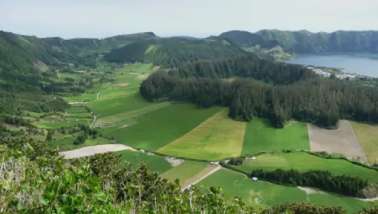
7 Cidades Ultimate Trail (7CUT) — São Miguel (May 2026)
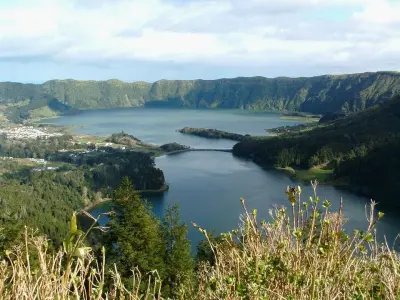
The 7CUT takes runners along the crater ridges of the Sete Cidades caldera — one of the most visually dramatic running environments in the world, with views down into twin lakes (one blue, one green) filling the volcanic crater below. Distances of 40 km, 20 km, and 10 km. Technically demanding due to wind-exposed ridgelines and wet terrain beside the lakes.
Trail dos Morcegos — São Miguel (September 2026)
September on São Miguel brings the Trail dos Morcegos, with distances of 36 km, 20 km, and 8 km (including a run/walk category and children's race). The course ascends Pico da Cruz for 360-degree island views. September conditions — minimal rain, excellent visibility, temperatures of 20–23°C — are ideal for longer distances. Registrations open several months in advance and sell out quickly.
Azores Triangle Adventure — Faial, Pico & São Jorge (October 2026)
A uniquely formatted event: three races, three islands, three consecutive days, with approximately 30 km per stage — over 90 km total. Inter-island boat transfers are included in the entry fee. The course covers Faial, Pico (with UNESCO-listed basalt-walled vineyards), and São Jorge (with coastal fajãs lava platforms). It functions simultaneously as a race and an expedition through the heart of the central Azores island triangle.
EPICX Azores by Decathlon — São Miguel (December 2026)
The longest and most internationally prominent event in the Azorean calendar. Held in December on São Miguel, finishing in Vila Franca do Campo, EPICX Azores offers distances of 100 miles, 100 km, 60 km, 30 km, and 15 km — plus night walk and day walk categories. December conditions are cool (14–17°C), with exuberant vegetation and waterfalls at full flow. Registration fees increase in March; early sign-up is strongly recommended.
Best Training Routes by Island
São Miguel
The largest island has the most extensive trail network. Key training routes:
- Sete Cidades Circuit (21 km / 900 m elevation gain) — A complete loop around the caldera lakes. Mixed terrain: compacted earth, paved sections, technical ridge lines. One of Portugal's top-rated routes on AllTrails.
- Sete Cidades – Pico da Cruz – Muro das Nove Janelas (23 km / 1,050 m) — Extended version including exposed ridge sections. Closely mirrors the 7CUT race profile.
- Lagoa do Fogo (12 km / 650 m) — Dense cryptomeria forest opening to views of the cobalt-blue Fogo Lake at 590 m. Excellent for climb-specific training.
- Pico da Vara (14 km / 850 m) — Highest point on São Miguel (1,103 m). Laurisilva forest, frequent summit fog, habitat of the critically endangered Azorean bullfinch (priolo).
Pico Island
Monte Pico (2,351 m) is Portugal's highest mountain and one of Europe's most impressive mountain running objectives. The official ascent covers approximately 7 km with 1,200 m of elevation gain — an average gradient of roughly 17%. Prior registration with the Pico Natural Park is mandatory (fee: €4). Conditions above 1,500 m change rapidly; gusts of 60+ km/h are common even when the coast appears calm. Allow a minimum of 5 hours before sunset when attempting the route.
Flores Island
The westernmost island of the archipelago has the highest concentration of waterfalls in the Azores — over 16 identified falls along established trail routes. The GR1 Flores covers most of the island in two stages (total approximately 70 km) and can be run as 30–40 km daily stages. The route passes Lagoa Funda, Lagoa Comprida, and the Poço da Ribeira do Ferreiro waterfall complex — among the most photographed landscapes in the Azores.
Faial Island
The coastal route between the Capelinhos Lighthouse and the Faial Caldera (5 km diameter, 400 m deep) is the reference training route for Ultra Blue Island preparation. The contrast between the lunar lava fields of Capelinhos and the dense laurel and Azorean holly forest inside the Caldera summarises Faial's geological and botanical diversity. The full circular route covers approximately 25 km with 900 m elevation gain.
Elevation Profiles: What to Expect
Volcanic terrain in the Azores produces highly irregular elevation profiles — very different from continental mountain races where altitude gain is typically gradual. Here, runners can move from sea level to 500–600 m in under 5 km. Key reference points:
- São Miguel (Sete Cidades): 0–850 m in 3–4 km segments
- Pico (summit route): 200 m to 2,351 m across 7 linear kilometres
- Faial (Coast to Coast 42 km): continuous variation between 0–600 m throughout the course
- Flores (GR1): repeated peaks between 0–800 m in a saw-tooth elevation profile
Cumulative elevation gain per kilometre in Azorean races consistently exceeds the European trail running average for equivalent distances. Runners should emphasise hill training in their preparation — and calibrate target pace expectations accordingly.
Practical Logistics for Runners
- Flights: International flights arrive at Ponta Delgada (São Miguel). For races on Faial, Flores, or Pico, internal SATA Airlines connections are required. Book early — inter-island flights sell out weeks before major events.
- Ferries: Regular ferry service connects Faial, Pico, and São Jorge (the "triangle route") with several daily departures. The Faial–Pico crossing takes 30 minutes. Always build buffer time — Atlantic winds can delay or cancel sailings.
- Kit: A lightweight waterproof jacket is mandatory equipment in all events, even in summer — ridge fog and lateral rain appear with little warning. Trail shoes with lateral grip for wet volcanic rock and mud. Poles are permitted and recommended for distances above 40 km.
- Humidity: The Azores regularly exceed 80% humidity. This significantly increases perceived exertion compared to equivalent continental effort. Adjust pace targets in early training sessions.
- Registrations: Most races open entries 6–9 months before the event date. Ultra Blue Island and EPICX Azores typically sell out within weeks of opening. Monitor official websites and social media channels closely.
- Accommodation: For Ultra Blue Island on Faial, Horta has limited hotel capacity — book 4–6 months ahead. São Miguel's Ponta Delgada has broad accommodation options at all price points.
FAQ: Azores Trail Running
What is the best time of year for trail running in the Azores?
April through October is the optimal window — lower rainfall, longer days, and temperatures between 18°C and 25°C. September and October are particularly valued: summer heat has eased, visibility is excellent, and trails are in their best post-summer condition. Winter running (November–March) is feasible but more demanding: frequent rain, heavy mud on forest trails, and reduced ridge visibility.
Do I need a guide to run in the Azores?
For main marked routes — Sete Cidades, Lagoa do Fogo, official PR trails — no guide is required. Waymarking is clear and routes are available on AllTrails and Wikiloc. For Monte Pico, park registration is mandatory and a running partner or local guide is strongly recommended. All official race courses are fully marked by organisers.
Can Monte Pico be run rather than hiked?
Yes. Experienced mountain runners complete the ascent and descent in 3–4 hours. The course record is under 2 hours. However, conditions above 1,800 m frequently include strong wind, cold temperatures, and poor visibility — safety must take precedence over any time objective. Never attempt the summit solo without adequate experience and equipment.
What distinguishes the Ultra Blue Island from EPICX Azores?
Ultra Blue Island takes place on Faial in May with a maximum distance of 115 km; EPICX Azores runs on São Miguel in December with a maximum of 100 miles (approximately 160 km). Both are internationally recognised events, but EPICX is longer and draws a higher proportion of elite ultra-runners. Ultra Blue Island is distinguished by its finish at the Capelinhos Volcano — arguably the most dramatic finish-line backdrop in Atlantic trail running.
Can trail running be combined with sightseeing in the Azores?
Without question — and this is one of the Azores' strongest assets as a trail running destination. Most runners arrive 3–5 days before their race to acclimatise and explore. The landscapes runners traverse during races — calderas, crater lakes, volcanic coastlines — are the same attractions that draw general visitors. After racing on Faial, many runners cross to Pico by ferry (30 minutes) to continue exploring the archipelago.